October is here and it’s time to take a look at this upcoming winter. Of course we can’t forecast with any sort of detail more than 7-10 days ahead of time, but we can glean a few general ideas each year. Buckle up, let’s call this “my thoughts” for the upcoming winter since I’ve got a few tidbits for you. This is NOT a forecast or really even an outlook.
THE HIGHLIGHTS
- Most likely we have a milder (warmer) than average winter on the way. But will it be mild + drier? Or mild + a soaker? Tough call.
- Long periods of cold/snow are unlikely this year
- But we could easily see a (1) snow or ice storm at some point, you should have a plan for that. If it happens, it would likely happen by mid-January at the latest. El Niño winters tend to give us mild Februarys (and March too). These winters don’t tend to drag on into early spring.
- Widespread regional flooding is unlikely this winter, more action heads south into California
- Expect a bit more east wind than normal this year in the usual spots east metro and Gorge
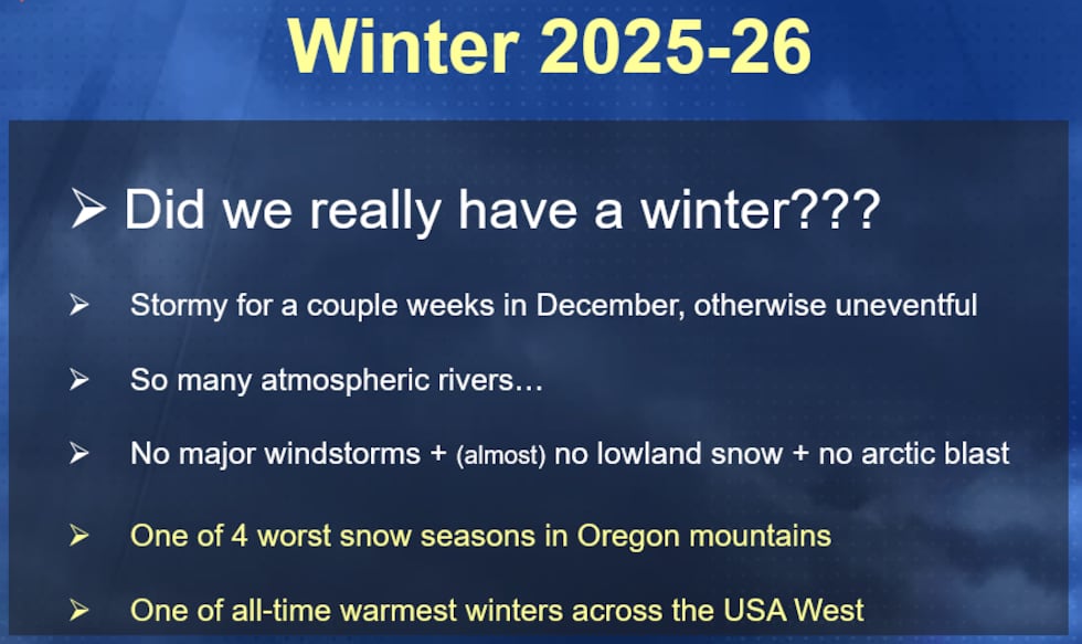
First, a quick recap from last winter…it was sooo boring for forecasters, plenty of sunshine for a 2nd consecutive year in January.
LOOKING AHEAD
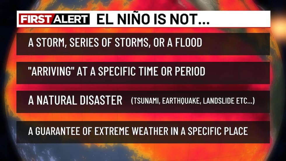
This will be my 35th winter forecasting in NW Oregon. I started forecasting professionally in October 1991 straight out of the University of Washington. Huge strides have been made in forecasting, but there is still plenty we don’t know about our climate and seasonal shifts in weather. Typically we focus on the La Niña/El Niño (ENSO) oscillation across the tropical Pacific and what that means for northern hemisphere winters. That is still the case, but other factors play into our winters such as the “Pacific Decadal Oscillation” and warming oceans. So each winter is different and lots more research is needed. There ARE some misconceptions about what El Niño is…
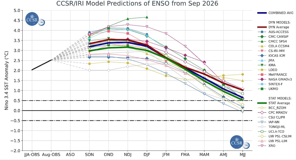
We are already in an El Niño episode and that continues through the winter. Right now it’s a “Super” El Niño based on the “Oceanic Nino Index”. Anything above +0.5 on this chart is considered El Niño, above +1.5 is STRONG, and +2.0 is VERY STRONG/SUPER (Super isn’t an official term). Notice all model forecasts peak and then weaken the event sometime next spring. That’s normal.
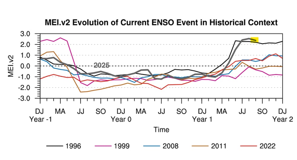
The Oceanic Niño Index chart above has a related cousin. The “Multivariate Index” takes both oceanic AND atmospheric variables into account; it’s considered a more “thorough” view of this phenomenon. Notice how strong the event is (so far) using this index. Stronger than the 97-98 event right now.
We tend to see a changed north Pacific jet stream during El Niño cool seasons, due to the mass of warm water to the south positioned a bit farther east than normal, plus some other changes. Typically the Pacific jet stream flows generally west to east and runs into the northern half of the USA West Coast, especially during La Niña winters. Thus the heaviest winter rains tend to fall in the Pacific Northwest, as opposed to California. There are exceptions of course.

But during most (not all!) El Niño winters we see the normally strong jet stream in the western/central Pacific push farther east towards North America. It’s barely noticeable on the graphic below because it’s a 3-month average.

When that happens, we see more wet systems into California AND more areas of upper-level high pressure pop up over western Canada. This causes a bit of a “split flow” in the Eastern Pacific, shunting arctic air farther east than normal, giving the Northern Plains a warmer than normal winter. Meanwhile that wet (and warm) westerly jet running into California gives them a wetter than normal winter. Remember this is all what is “typical”.
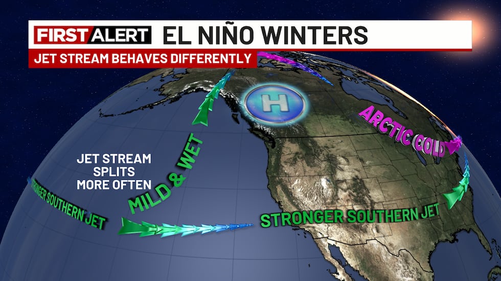
Notice the Pacific Northwest sees a mix of weather. The northern part is strongly influenced by the upper-level high in Canada, the southern part (southern Oregon) often gets in on the edge of the California moisture action. As a result, southern Oregon ski areas and basins receive normal or even above normal precipitation in many El Niño years.
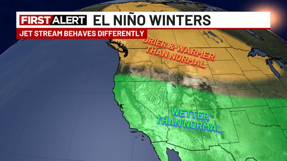
It’s important to point out that though many El Niño winters follow this pattern, sometimes they don’t . No guarantees! It has also been noted that in the very strong El Niños (this year!), the heavier precipitation appears to make it farther north (example: Winter 2015-16). Both 1982-83 and 1997-98 (strongest since 1950) both featured near or above normal rainfall even up here in Portland. Look at 3 very strong El Niño wet seasons…wetter than normal.

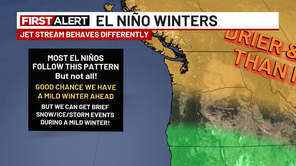
Of course what everyone really wants to know is…will it snow at MY house this winter???
A misconception to get rid of is that a warmer and possibly drier than normal winter means no snow in the lowlands; not true at all. Check out the last 10 El Niño winters (not just strong events):
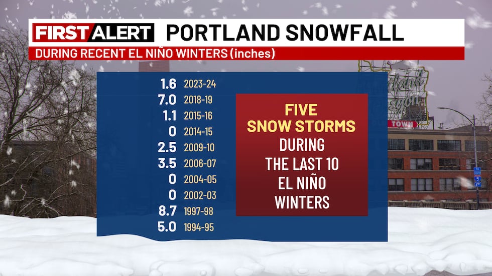
Example A is what we all remember from 2023-24. A very mild winter, but then a crazy 8 days in mid-January. Extreme cold, plus wind and freezing rain brought the Portland area to a halt. We saw our coldest day in 30+ years. Then the mild winter resumed. That was a strong-ish El Niño winter.
We had a similar event (big, but brief snowstorm) in January 1998, a “super El Niño” as well. I distinctly remember shoveling feet of drifted snow in eastern Multnomah county in January 1998 under a “hot” 50 degree sun once the east wind stopped and the mild winter resumed.
To summarize, It’s unlikely we have a snowy/cold winter ahead (like Winter 2016-17), but it’s quite possible we get some sort of freezing rain or snow event once during the upcoming winter. And I’ve noticed when we get those in these warm winters, they almost always occur by mid-January, not later.
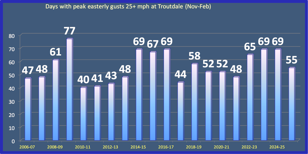
One more point…one of the most hated parts of winter for part of the metro area is the cold east wind. The Columbia River Gorge produces what we call a “gap wind” when high pressure east of the Cascades sends air rushing through the sea-level gap through the mountains. The east side metro near and south of the Columbia River is fully exposed to the wrath of this wind. It begins to appear in late October and reaches a peak from November through February. Then the wind disappears in early March as the seasonal westerlies begin. The last 17 winters at Troutdale airport below. Any day with an easterly gust over 25 mph counts.
Does El Niño mean more or less east wind? Based on my experience, it’s generally a case of MORE east wind. That’s because during El Niño years, we have a split or blocked jet stream more often, leading to more time under surface high pressure. And much of the time that is centered east of the Cascades. Notice plenty of east wind during El Niño events in 2009-10, 2014-15, 15-16, and 23-24.
SUMMARY
- Most likely we have a milder (warmer) than average winter on the way. But will it be mild and drier, or a soaker? Tough call, I’m leaning towards wet
- Long periods of cold/snow are unlikely this year
- But we could easily see a snow or ice storm at some point; you should have a plan for that. If it happens, it would likely happen by mid-January at the latest. El Niño winters tend to give us mild Februarys (and March too).
- Widespread regional flooding is unlikely this winter, more action heads south into California
- Expect a bit more east wind than normal this year in usual spots east metro and Gorge
THE WILDCARD THIS YEAR
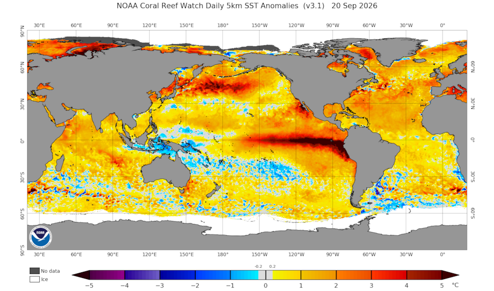
One item that’s different than many previous El Niños is the widespread warmth across most of the global oceans. Of course I mean warmth compared to normal. There is some speculation that this El Niño could be different because that large area of very warm water in the equatorial Pacific is surround by lots of warm water elsewhere. Could that prompt a different atmospheric response this year? Maybe upper level ridging in a different place instead of western Canada? Look at almost the entire northern Pacific with well above normal sea surface temps! In a most El Niño events, the warmth in the equatorial Pacific really sticks out. This year that warmth is surrounded by many areas of warmer than normal ocean waters.
In Tuesday’s post (10/13) I’ll take a look at what we might see in the Cascades and how this all might affect the ski season.
Copyright 2023 KPTV-KPDX. All rights reserved.