4 things to know about the weather:
- Temps cooler after Wednesday afternoon storms
- Heat index as high as 105° Thursday
- Severe storm risk returns
- Cooler air arrives Saturday
Severe storms moved through the area earlier today, but will continue to move out of the region to the south.
Temperatures peaked in the low to mid 90s Wednesday afternoon, but have fallen fast after heavy rain.
More storms and heat
Thursday will likely be the hottest day of the week with highs in the mid- to upper-90s and a heat index as high as 105°! That’s crazy for Sept. 3.
In addition, that extreme heat and humidity will also lead to an even greater risk for severe storms. Storm Team4 will most likely be in weather alert mode Thursday.
Download the NBC Washington app on iOS and Android to check the weather radar on the go.
A cold front will reach the area on Friday. Ahead of the front, most areas will once again climb into at least the low 90s with rain and thunderstorms likely to impact the entire area at some point in the afternoon. There will be a severe weather concern on Friday as well, but that will be the last day of this steamy and stormy stretch.
That cold front will be to our south by Saturday morning, bringing an end to our rain chances. Highs on Saturday will return to the mid-80s which is average for the season.
Sunday and Monday will be very pleasant days for outdoor activities: highs in the low 80s and overnight lows in the 50s and low 60s. There are some signs of the 90s returning by the middle of next week, but we’ll worry about that later. For now we just need to stay cool and stay alert for those afternoon storms chances.
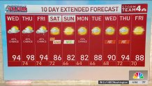
QuickCast
WEDNESDAY:
Hot and humid
Heat index nearing 100°
Strong/severe PM Storms
Wind: east/southeast5-10 mph
Chance of rain: 40%
HIGHS: 90° to 95°
WEDNESDAY NIGHT:
Scattered evening storms
Drying after midnight
Warm and very muggy
Wind: southeast/south 5 mph
Chance of rain: 20%
LOWS: 72° to 78°
THURSDAY:
Dangerously hot and humid
Heat index above 105°
Strong/severe pm storms likely
Wind: west/southwest 10 mph
Chance of rain: 60%
HIGHS: 94° to 99°
FRIDAY:
Hot and humid
Heat index near 100°
Rain, thunderstorms likely
Wind: northwest 10 mph
Chance of rain: 60%
HIGHS: 88° to 94°
SATURDAY:
Sun and clouds
Early AM shower possible
Cooler, less humid afternoon
Wind: north 5-15 mph
Chance of rain: 20%
HIGHS: 82° to 87°
Sunrise: 6:38 Sunset: 7:37
Average High: 85° Average Low: 68° See less